Lassen Peak trip

My Nissan Leaf Forum

Help Support My Nissan Leaf Forum:

This site may earn a commission from merchant affiliate links, including eBay, Amazon, and others.

edatoakrun

Well-known member
Joined
Nov 11, 2010
Messages
5,222
Location
Shasta County, North California
So, I drove the Leaf to Lassen Park on Sunday.

P7310012.jpg


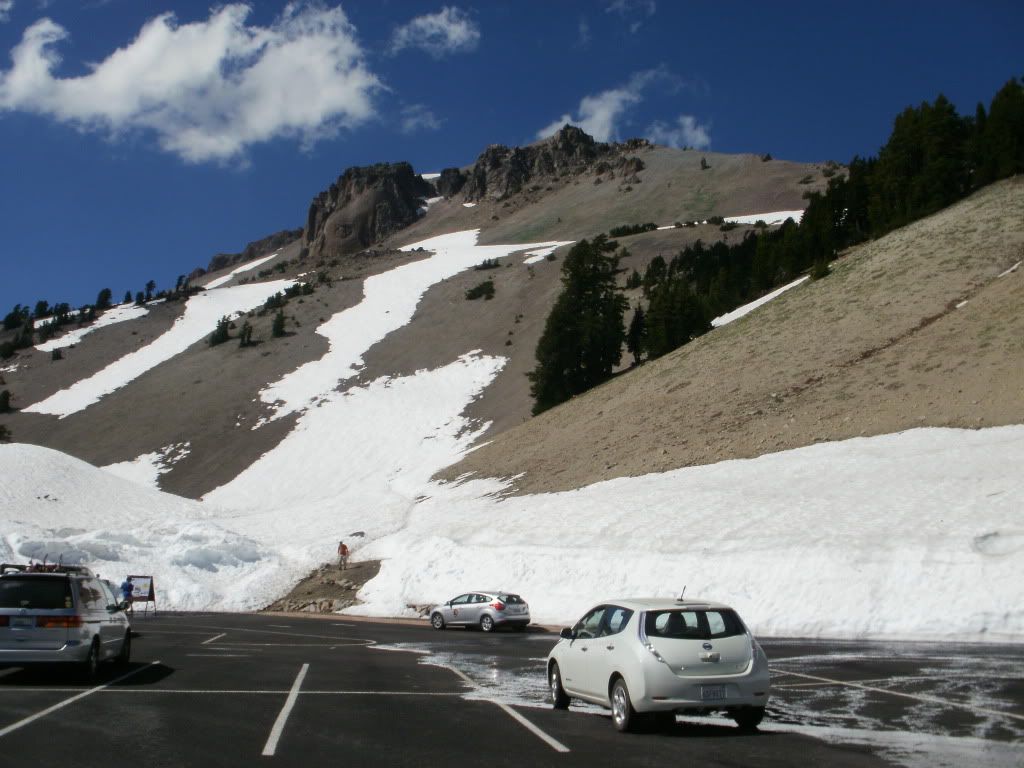
Still quite a lot of snow at 8,500 ft. The trail to the Peak was partially closed. It's only open intermittently while being reconstructed. I took a very nice hike to Echo lake, instead.

You probably wouldn't be able reach the Park entrance From Redding via hwy 44 on a single charge (about 47 miles and 8,000 ft of ascent) (edit-should read: about 47 miles and 5000 feet of ascent, then another 3,000 feet and 21 miles to the peak trail parking lot, where the photo was taken) and there are currently no (official) charge points in the Park. I would suggest a recharge at Shingletown, where there are several likely RV parks. Mt Lassen KOA offers a $10 flat Fee 240 V recharge, if you have a portable EVSE. The Managers, Al and Jean Butzine, are very receptive to EV visits, especially if combined with campsite or cabin rentals, so you might want to overnight. From Shingletown, (4000 ft) you can make it the last 30-something miles to the summit with 3-4 bars left, and return to Redding on the same charge with a few bars left, if you limit your speed to 50-55 mph both ways.

My trip from my home (near Oak Run, 2,000 ft altitude) was a little longer, 144.4 miles round trip, about 11,000 ft. total and 6500 ft. net ascent and descent. I recharged from 3 to 12 bars near Shingletown, at a Friend's cabin on the way up. I'd hoped to make the 94.5 miles to the peak and back home on this one charge, taking advantage of the 2,000 ft net descent, but it became clear I'd need to drive well under 50 mph to do so, so I stopped on the way back, charged from 4 to 8 bars, and still had 3 when I got home.

From this and other long climbs and descents I've made, my rule of thumb is now each 800 ft of ascent consumes about one bar, and each descent of 1,000 ft adds one bar. This is assuming road and traffic conditions permit Regen to do most of the braking, and you have 10 bars or less of charge, so full regen is available.

I would not have thought near 80% recovery of ascent energy (by both "coasting" and regen) likely in real-world use on extreme grades, but that's what I'm seeing, and it seems other recent hill climb threads reflect the same experience.
 
NICE! Great pic too!

edatoakrun said:
From this and other long climbs and descents I've made, my rule of thumb is now each 800 ft of ascent consumes about one bar, and each descent of 1,000 ft adds one bar. This is assuming road and traffic conditions permit Regen to do most of the braking, and you have 10 bars or less of charge, so full regen is available.

That's good data. Thanks.
 
Thanks for the post! (I just noticed it.) Looks like there is a bit less snow than when we were there in mid-June of this year:

img1927j.jpg


We were truly impressed by Lassen park and intend to return within a year or two. Thanks for documenting your LEAF experience there.
 
abasile said:
Thanks for the post! (I just noticed it.) Looks like there is a bit less snow than when we were there in mid-June of this year:

img1927j.jpg


We were truly impressed by Lassen park and intend to return within a year or two. Thanks for documenting your LEAF experience there.

And I just noticed an error in my post (about 47 miles and 8,000 ft. of ascent) should read (about 47 miles and 5000 feet of ascent).

It's another 3,000 feet and twenty-something miles to the peak parking lot, where the photo was taken.

The road is rarely cleared of snow before July, and was opened this heavy-snow year only at the end of July.

Lassen is a great place, and one of the least-visited National Parks, even though it's only an hour drive from I-5.
 
edatoakrun said:
And I just noticed an error in my post (about 47 miles and 8,000 ft. of ascent) should read (about 47 miles and 5000 feet of ascent).

It's another 3,000 feet and twenty-something miles to the peak parking lot, where the photo was taken.
Thank you for the clarification, though I sort of figured that's what you meant since the park entrances are below 6000 feet elevation.

I wonder if you might be able to charge at the campground near the North entrance, either at an RV campsite or a park building. (We stayed there, and shopped for supplies in Shingletown.) I know you were trying to get permission to charge at Lassen. Did you get anywhere with that?

Despite my repeated inquiries, Joshua Tree National Park would not agree to let me plug in the LEAF anywhere, even at 120 V and even if I made a donation (see http://www.mynissanleaf.com/viewtopic.php?f=7&t=3025" onclick="window.open(this.href);return false;). I'm not sure if that's because of Federal policies (see http://www.mynissanleaf.com/viewtopic.php?f=7&t=2667#p59459" onclick="window.open(this.href);return false;), or just because the Park management didn't want one more thing to worry about. It would be nice if the Lassen management proves to be more accommodating.
 
abasile said:
I wonder if you might be able to charge at the campground near the North entrance, either at an RV campsite or a park building. (We stayed there, and shopped for supplies in Shingletown.) I know you were trying to get permission to charge at Lassen. Did you get anywhere with that?

No.
 
Update-

I never made it back to the Lassen Peak trailhead in my LEAF last Summer, but did visit Lassen park by taking the longer highway 299 to 89 to 44 route, looping around the Thousand Lakes Wilderness. There is an RV park at Hat Creek for L2 (See recargo for details) if anyone wants to drive this route.

Below is my trip profile on highway 44 to the Peak trailhead lot. If you take Highway 44 from Redding, you'll pick up this profile at ~mile 20 miles, at the intersection of highway 44 and "old highway 44". There are several RV parks at ~mile 40 on this profile, including the Shingletown KOA. They are also at ~40 miles on this profile (but more like ~3,800 ft of total and ~3500 ft net ascent) from Redding.

1357252213-20508_zps484af40a.png


From the trailhead it's one of Gorp's "top ten" day hikes to the Peak:


4. Lassen Peak

5-mile circuit in Lassen Volcanic National Park , CA
Almost 65 years to the day before Mount St. Helens blew its top, Lassen Peak, the southernmost active volcano in the Cascades, exploded violently and spewed ash that landed 200 miles to the east. Today, the ninth-highest volcano in the Cascades is dormant, but the scent of sulfur still seeps from its cracks. It also makes for one of the most accessible summit day hikes in the Pacific Northwest. A short-but-steep five-mile out-and-back trip culminates with spectacular 10,457-foot-high views into the destruction from almost a century ago. The trail begins at a parking area at about 8,500 feet up the volcano. Follow a series of switchbacks and steep pitches up the southeastern ridge for about 2,000 vertical feet to reach the airy summit. From there, find a rock on which to kick back and take in the views of cinder cones and the remnants of some 30 volcanic domes that make up the park. The peak can get more snow than many other surrounding areas—upwards of 40 feet—meaning the main road into the park can be closed much of the year. It's best to go in mid-July.

Read more: http://www.gorp.com/parks-guide/travel-ta-top-hikes-in-pacific-northwest-sidwcmdev_154815.html?page=2#ixzz2GxvjmGQV" onclick="window.open(this.href);return false;

I was lucky to get there (BY ICEV) last August (on one of the few days the trail was open last summer) and walked to the top.
 
Love it! Thanks for the report. We hiked the Lassen Peak trail last summer, but had to turn around about halfway to the summit due to the trail closure. It was still an awesome little hike, though. Of course, we did not have the pleasure of using the LEAF; our conveyance was the Prius.
 
Almost two years after my first trip to Lassen NP in my LEAF, I made it back to the Peak.

Lassen was great, as always, especially since the temperatures on Valley floor that day were reported to be as high as 113 F! I had lunch at the peak, then back-tracked to ~6,700 ft. (at the end of trip 4, at point D) to find a snow-free trail for a hike.

I think my earlier inexperience with large ascents and descents (must be pretty close to 13,000 ft. on this route) may have made the trip seem harder than it was, as I described it two years ago. Redding to the Peak and back is certainly manageable with one ~12 to 15 kWh recharge at ~4,000 ft elevation, as long as you take reasonable measures to drive efficiently (slowly!) on the trip.

I'd encourage everyone driving through the North State to visit one of the most under-appreciated National Parks, and one relatively easy to access (with a portable EVSE) in a BEV.

The Peak trail is scheduled to be open over this Fourth of July Weekend, BTW, offering one of the few opportunities to climb the Peak, before the trail project is completed in 2015.

I had a much easier time with the range-planning this time, having a lot more experience with large ascents and descents, having the ability to read the nav screen m/kWh and knowing my remaining kWh to the LBW and VLBW to within a few hundred Wh of accuracy. I still haven't figured out any way to use the Battery app to get usefully accurate Wh use reporting. For example, the app reported ~250 Wh use while I was sparked at the Peak lot!

Benefiting from the ~2,000 ft. net descent, I did the last 109.3 miles of the 154.3 mile trip from a single recharge to "100%" at the 45 mile, ~4000 ft. elevation point, I got to the Peak and back home (using only one charge bar for the 77 mile ~6,400 ft. net descent from the Peak!) with two bars left, and probably ~2 (nominal, Dash/nav screen/CarWings) kWh left before the VLBW, at the end of the trip.

Next time, I won't wait for the slow top-off to "100%" at the recharge.


Back at the Peak trail lot, on 6-8-13. Drought watch- there is not much more snow than there was on my first trip ~7/30 of 2011.


Here is my route:


Excluding the first ~.3 miles and ~150 ft of descent, and the same distance and ascent on the trip end, Which Google will not map.

Here is the elevation profile for that route:


Here is a screenshot of the CarWings ERS kWh use report for 6/8/13:


="abasile"
I wonder if you might be able to charge at the campground near the North entrance, either at an RV campsite or a park building...
An update.

Lassen NP is currently considering putting in charging facilities!

Amanda Sweeney is LVNP's contact for the project, so if you'd like to make comments or suggestions, you can reach her at:

[email protected]

530-595-6134

I believe that none of Lassen's campgrounds have power. But LNVP is, IMO, ideally suited for L2 installations, as there are low elevation visitor centers with electric service, at both ends of Highway 89, which crosses the park from North to South.

At the North (main?) Entrance there are hiking trails and an interpretive center at Manzanita Lake, which would give you plenty to do, while waiting for the recharge to get to the higher elevation attractions.

If you have a Park near you, that you would like to see install charge sites, you might want to look at this old thread:

Getting charged at the end of the road- Parks
http://www.mynissanleaf.com/viewtopic.php?f=7&t=3025" onclick="window.open(this.href);return false;
 
Great video, introducing LVNP in 4 minutes...

https://www.youtube.com/watch?v=eUFeXGpnXO8" onclick="window.open(this.href);return false;

Of course, much better to see it for yourself, and no better way, IMO than in a LEAF.

You not only can enjoy the Park, but after experiencing 80% to 90% recovery of ascent energy over the (~8,000 ft net ascent) trip, you will never fear hills again.

The Peak road is only open late Summer through early Fall, but since quite a few LEAFs now seem to be making the ~I-5 trip through North California, I encourage you to get off the corridor.

I made three trips to the Peak trailhead last Summer (recharging at ~mile 47, the second red line on the profile) the last two times returning Via highway 36:


HWY 36 is actually easier to drive efficiently (that is-slowly) than HWY 44, as it has no 65 mph zones and more passing opportunities.

To do this trip Redding-to-Lassen Peak-to-Red Bluff with only one charge stop (near Shingletown, and near 4,000 ft. elevation) you will probably have to drive below prevailing speed on some of the higher-speed stretches of highway.

To give you an idea, I drove my route the first time in 5 H 47 m total drive time (as compared to the
Google 4 h 22 m (add another ~ 5 minutes to that for the ~0.7 m of my driveway off the map) estimate.

Not knowing some of the route, I drove much too slowly, and got the LBW less than a mile from home.

The second trip, cooler temperatures, on nearly new tires (both reducing efficiency) I made it in 5 H 32 m, arriving at my door well before the VLBW, as per plan.

112+ miles on a single charge is much easier, when you recharge above your destination, and have ~2,000 ft. worth of (potential) energy backing up your battery!

Redding to Redding, or Redding, to Red Bluff, are both shorter and require ~1,500 ft. less descent and ascent and than the trips I make, so you shouldn't have trouble driving either on a warm day.

And most days the road is open over the Peak, it is warm, 90 F to 110 F down in Redding and Red Bluff.

The Upstate California Plug-in Electric Vehicle Readiness Plan shows a DC in Shingletown on their map:

http://www.schatzlab.org/projects/policyanalysis/pev/upstate/charger-map.html?scenario=2" onclick="window.open(this.href);return false;

http://www.mynissanleaf.com/viewtopic.php?f=51&t=3319&start=20" onclick="window.open(this.href);return false;

Which of course would save hours of LEAF recharge time on any Lassen trip .

But I wouldn't wait for it...
 
Highway 89 is closed at the North and south Park entrances until next Summer, assuming we get at least normal snowpack this Winter.

http://www.nps.gov/lavo/planyourvisit/current_conditions.htm#CP_JUMP_218946

I've seen the preliminary draft for the Charge station grant application I mentioned last Summer, and it requests funding to put dual L2s at both North and South Park entrances.

Cross your fingers...

Due to drought, the road was plowed early this year, and I made three trips over the Peak road, on 6/12, 6/30 and 8/19, all variations on the Hwy 44/89/36 loop I posted above, all from 160 to 161 miles, total ascent and descent between 13,400 and 13,600 ft.

I got home after each trip with kWh to spare, well before the VLBW with 33 or 34 gids indicated after each trip, having recharged to "100%" at ~47 miles and ~4,000 ft. on the way up, so I'd expect to be able to make this trip (on warm days, at low speed) for at least a few more years on my OE pack.

BTW, after an ascent/descent like this gives you some interesting dash displays.

Descending from the ~8,500 ft. Peak, my LEAF's dash display went from 1 to 6 Charge bars and from 4 miles on the GOM to 57 and 56, after ~37 and ~30 miles driven respectively. Anyone driven other roads where you can regen that much?

The Peak trail has been rebuilt and is consistently open (during the 3-4 months the highway is open) but on 8/19 the smoke was thick enough that I didn't want to put my lungs to the test.

This photo of the Peak from ~5 miles away was taken from the Echo lake trail.

 
Thanks for sharing. Hopefully by next summer, the drought will have moderated some and the air quality will be good enough to fully enjoy the Peak trail.

edatoakrun said:
Descending from the ~8,500 ft. Peak, my LEAF's dash display went from 1 to 6 Charge bars and from 4 miles on the GOM to 57 and 56, after ~37 and ~30 miles driven respectively. Anyone driven other roads where you can regen that much?
That's pretty impressive! Even with all of my mountain driving, I don't think I've ever gained more than four charge bars from regen. One limitation I face in the SoCal mountains is traffic - it's usually not possible to drive slowly enough to get maximum regen.
 
abasile said:
...
edatoakrun said:
Descending from the ~8,500 ft. Peak, my LEAF's dash display went from 1 to 6 Charge bars and from 4 miles on the GOM to 57 and 56, after ~37 and ~30 miles driven respectively. Anyone driven other roads where you can regen that much?
That's pretty impressive!...
Perhaps more impressive, is that any LEAF could begin a trip from the Lassen Peak summit parking lot and arrive at the I-5 corridor anywhere from Red Bluff to Redding, 65 to 75 miles away, with more energy in the pack than it started out with.

Start the trip at turtle if you like, for dramatic effect!

From ~mile 120 on my trip profile above you could ~follow Battle Creek east, avoiding the major ascents I need to make to get home.

With ~12 kwh of potential energy (depending on vehicle load) from the Peak lot to the Valley floor, and ~90% rate of recovery (blend of regen and direct) you'd need to drive at a ~6.5 m/kWh average speed (level) to make 70 miles with no net energy use.

For comparison, on all three ~161 mile loop trips this year, my LEAF reported 7.0 or 7.1 odometer miles/nominal kWh (what is shown in the nav screen m/kWh display).

No, My LEAF did not really get 7.0 or 7.1 m/kWh on each of these trips, or even the 6.7 or 6.8 shown on the dash M/kWh display, caused by it's 2.5% underreport error from odometer miles.

But I estimate that my LEAF did get a very respectable ~6.3 to 6.4 actual m/kWh, once correcting for both the underreport in my odometer, ~0.5%, and the underreport in my LEAF's kWh use, ~10.5%.

A ~6.5 m/kWh actual pace should be pretty easy to achieve on several slower average speed routes from the Peak lot to I-5, on a warm day.

The more weight you have in your LEAF, the easier this trip would be, of course.
 
Some more info for anyone wanting to plan a drive up to Lassen next year.

I estimate my LEAF used ~22.7 actual kWh to reach the ~8,500 ft. Lassen Peak lot, and ~25.2 actual kWh to make the entire ~161 mile ~13,600 ft. total ascent/descent trip, when I last dove this route on 8/19/15.

Which is why I would have needed to recharge en-route back in 2011, when My LEAF had ~21 actual kWh available, and need to even more so now, (~4.5 years and ~41,000 miles later) since my pack now only has ~18 kWh available to turtle.

I expect the 30 kWh pack probably has ~27 kWh available, so I'd probably be able to make ~the same trip at ~the same speeds on a single charge, in a 2016 SV or SL.

A loop trip from I-5 (there are two motels with L2s in Anderson) could only be ~127 miles:

https://www.google.com/maps/dir/40.4532498,-122.2896598/Lassen+Peak,+Mineral,+CA/40.453422,-122.2891447/@40.4540788,-122.0264622,11z/data=!4m25!4m24!1m10!3m4!1m2!1d-122.0743585!2d40.3973651!3s0x54d2b7a9ecb95911:0xe6d74668e2e645f1!3m4!1m2!1d-121.9273461!2d40.3714418!3s0x54d2b39a2b42fb89:0xb3b35c83fce96877!1m10!1m1!1s0x54cd525f76f62679:0xc61644fd01052593!2m2!1d-121.50493!2d40.4880757!3m4!1m2!1d-121.6702444!2d40.5285523!3s0x54cd573785daec27:0x261cf82a41536206!1m0!3e0

If you were to drive very slowly on a warm day, you could probably do this trip on as little as ~21 kWh, but I wouldn't suggest trying it, even in a 24 kWh 2015, which is both more efficient and probably has slightly higher kWh than My LEAF had when it was new.

It should be quite easy to do this trip with kWh to spare, in a 30 kWh 2016, if you allow closer to 4 hours drive time, rather than the 3 hours 17 minutes show above by google.

BTW, I just noticed this Fully Charged episode showing the 30 kWh LEAF's excellent performance in Mountainous conditions:

https://www.youtube.com/watch?v=1rXGE06euXA
 
I have found both or your mountain trip reports very helpful to our adventures. Your reports prompted me to report on our intercity trips, many of which I've posted here. All are up on my web site.

So, again, thanks for the reports.

And we hope to do Lassen some day.

Paul
 
paulgipe said:
...we hope to do Lassen some day.

Paul
You're welcome (belatedly) Paul.

Those considering planning a trip the 2016 season can get road updates at the site below.

Looks like the highway may be open all the way to the summit by ~the end of May.

2016 Road Clearing Operator's Log

April 25 - Thursday, we were able to clear to about 500 feet short of Jones Cut (about 3 miles from the Kohm Yah-mah-nee Visitor Center), today when we arrived it was snowing with very high winds and near zero visibility so I decided to call off the effort until tomorrow. If all goes well, I anticipate getting near to Bumpass Hell Parking Area (6 miles) by the end of next week...
https://www.nps.gov/lavo/planyourvisit/winter-road-closures-and-spring-clearing-update.htm
 
New! The road through the park will open in its entirety June 12, 2016
https://www.nps.gov/lavo/planyourvisit/winter-road-closures-and-spring-clearing-update.htm

The Clean Cities grant proposal for four level 2 charging stations (two each at both North and south entrances) was approved.

Park officials are planning on a 2017 spring/summer installation.

Here's the view from Crags lake on 6/1/16. The trailhead is one of several near the proposed Northern L2 site.


Below is Mill Creek Falls, in a photo taken 8/24/14.

The trailhead starts at the South visitor center, where the other L2 site will be located.

 
Update on Lassen Peak.

Road open!

At last, Lassen park road set to reopen to through traffic

The road through Lassen Volcanic National Park finally will reopen to through traffic Thursday after nearly four months of snow-clearing work.

Thursday's road opener set a record for the latest opening date, park officials said.

"This year's opening of the highway will be the latest in park records dating back to 1931," Lassen Superintendent Jim Richardson said.

Since 1980, the latest opening was July 21, 1995, according to park logs.

The delay was caused for the most part by a snowy winter with the snowpack persisting into summer.

The final north-south section of the 30-mile Lassen Volcanic National Park Highway that needed to be plowed was between the Lassen Peak parking area and Summit Lake...

Snowfall in the park was about average for winter but it was more than the previous four years during the drought, Haner said earlier this month. A total of 28 feet of snow was reported over the winter at the summit of the park highway, which connects with Highway 89 at the park boundaries...
http://www.redding.com/story/news/local/2017/07/26/last-lassen-park-road-set-reopen-through-traffic/514709001/

All the images on my previous posts have been photobucketed, sorry about that.

Here is a link to the route I often drive, ~161 miles and ~11,600 ft of total ascent and descent, recharging once on the climb:

https://www.google.com/maps/dir/27772+Hopper+Ln,+Oak+Run,+CA+96069,+USA/40.5009672,-121.7424921/40.4747783,-121.5056816/40.4487272,-121.5357011/40.3374315,-121.9139204/27772+Hopper+Ln,+Oak+Run,+CA+96069,+USA/@40.6130966,-121.809082,9z/am=t/data=!4m28!4m27!1m10!1m1!1s0x54d29d60b7636061:0x3e3d482e08918a39!2m2!1d-122.018653!2d40.718518!3m4!1m2!1d-121.8949619!2d40.6322388!3s0x54cd6006a5816421:0xdfb6135cf523b04d!1m5!3m4!1m2!1d-121.7424921!2d40.5009672!3s0x54d2a8271d4a9541:0x130e31f8f5b5eb41!1m0!1m0!1m0!1m5!1m1!1s0x54d29d60b7636061:0x3e3d482e08918a39!2m2!1d-122.018653!2d40.718518!3e0

Both times I drove this route last Summer (2016) I got the LBW just before the summit, and made it home after another ~81 miles, without reaching the VLBW.

As mentioned previously, it should be fairly easy to make the shorter trip from the I-5 corridor to the peak and back without having to recharge, if you have a "30 kWh" LEAF, choose a low-speed route, and drive conservatively.

Which you may want to (or need to) plan on, since the Park's plans to install L2 sites have reportedly been cancelled.

Here again is one ~127 mile route I suggested above:

https://www.google.com/maps/dir/40.4532498,-122.2896598/Lassen+Peak,+Mineral,+CA/40.453422,-122.2891447/@40.4671397,-122.1397587,11z/data=!4m25!4m24!1m10!3m4!1m2!1d-122.0743585!2d40.3973651!3s0x54d2b7a9ecb95911:0xe6d74668e2e645f1!3m4!1m2!1d-121.9273461!2d40.3714418!3s0x54d2b39a2b42fb89:0xb3b35c83fce96877!1m10!1m1!1s0x54cd525f76f62679:0xc61644fd01052593!2m2!1d-121.50493!2d40.4880757!3m4!1m2!1d-121.6702444!2d40.5285523!3s0x54cd573785daec27:0x261cf82a41536206!1m0!3e0

PS:

I just noticed that the ~10 miles of unpaved Spring branch road above, the only segment which I've never driven myself, looks fairly rough in satellite view. I suggest you find current road conditions before planning that route.

Or instead try this ~133 mile route , which looks to be entirely paved, though in parts only one lane wide:

https://www.google.com/maps/dir/40.4532498,-122.2896598/Lassen+Peak,+Mineral,+CA/40.453422,-122.2891447/@40.4382373,-122.2080197,30350m/data=!3m1!1e3!4m30!4m29!1m10!3m4!1m2!1d-122.116483!2d40.4443265!3s0x54d2b8575bab3ff9:0xff34270c9913aa88!3m4!1m2!1d-121.9273461!2d40.3714418!3s0x54d2b39a2b42fb89:0xb3b35c83fce96877!1m15!1m1!1s0x54cd525f76f62679:0xc61644fd01052593!2m2!1d-121.50493!2d40.4880757!3m4!1m2!1d-121.6702444!2d40.5285523!3s0x54cd573785daec27:0x261cf82a41536206!3m4!1m2!1d-122.1753723!2d40.4776343!3s0x54d2bf3a4fe1ac35:0x1a55faa85df72823!1m0!3e0
 
Back
Top