TheMagster
Member
- Joined
- Sep 1, 2018
- Messages
- 23
I'm curious if anyone knows of a project for mapping out EV-friendly spots for extended roadtrips? Here's the few I know of:
Plugshare - app for finding public charging stations, seems to be the best option I've found. Relies heavily on community input. Specifies Level 1, 2, or 3 charging, and allows for filtering of the level you prefer.
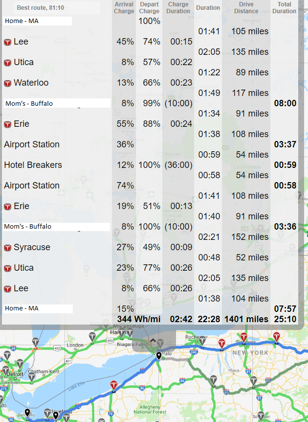
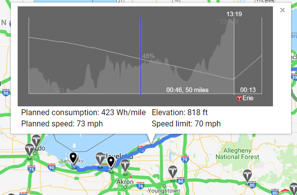
NissanConnect formally CarWings - official app by Nissan that includes a route planner, which takes into account the current state of charge of your vehicle and maps out your path with suggested charging stations and charging times. The route you choose can also be sent to your Leaf's nav system, which is very convenient. Major downside is that it is very slow to calculate a route and clunky to use (doesn't even remember your home address!).
evtripplanner.com - Website that helps you plan your route to hit various charging stations, based on Google Maps. Nissan Leaf support is still in beta and not very fleshed out...it will show you charging stations and calculate charging times as you manually select charging stations, but it won't suggest a route for you, and it doesn't discriminate between Level 2 and Level 3 charging.
What other resources do you use that aren't on this list?
The above tools can help you get by well enough, but they are effectively just tools for finding charging stations along your route. What I'm really interested in is a project that maps out EV-friendly cafes, diners, motels, campsites, and so forth. Places that won't bat an eye if you want to plug into an external 120V outlet, for example.
Anyone know of such a thing? Or should I start one?
Plugshare - app for finding public charging stations, seems to be the best option I've found. Relies heavily on community input. Specifies Level 1, 2, or 3 charging, and allows for filtering of the level you prefer.
NissanConnect formally CarWings - official app by Nissan that includes a route planner, which takes into account the current state of charge of your vehicle and maps out your path with suggested charging stations and charging times. The route you choose can also be sent to your Leaf's nav system, which is very convenient. Major downside is that it is very slow to calculate a route and clunky to use (doesn't even remember your home address!).
evtripplanner.com - Website that helps you plan your route to hit various charging stations, based on Google Maps. Nissan Leaf support is still in beta and not very fleshed out...it will show you charging stations and calculate charging times as you manually select charging stations, but it won't suggest a route for you, and it doesn't discriminate between Level 2 and Level 3 charging.
What other resources do you use that aren't on this list?
The above tools can help you get by well enough, but they are effectively just tools for finding charging stations along your route. What I'm really interested in is a project that maps out EV-friendly cafes, diners, motels, campsites, and so forth. Places that won't bat an eye if you want to plug into an external 120V outlet, for example.
Anyone know of such a thing? Or should I start one?